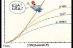
Neverending Covid-19 Coronavirus


This map essentially shows where Americans did not stay home and traveled more often than what was essential. Meaning other than buying essential goods, food and going to work.
Are you sure it doesn't include all movement? I don't know how they would be able to remove going to the store and/or work.
 
Are you sure it doesn't include all movement? I don't know how they would be able to remove going to the store and/or work.

It probably does. But you can see where people are only doing what is essential and staying at home the map is gray. Where it's red people are moving around like nothing has changed. Where it's orange people are moving around at near mormal levels.
 
It probably does. But you can see where people are only doing what is essential and staying at home the map is gray. Where it's red people are moving around like nothing has changed. Where it's orange people are moving around at near mormal levels.
That's true, but there are a lot of poor/middle class people in those areas, and unless they got laid off, going to work is absolutely essential to them, which I think can explain a lot of the data. I think maybe less shift workers have been laid off in the South due to the fact that the states haven't issued stay home orders, or at least have issued less strict ones.
 
I'm not trying to crap on the data or the analysis or anything, it just seems so incredibly complex, I think it is difficult to draw assumptions from it. For instance, in addition to what I already noted, could it have something to do with where the largest percentages of jobs that people have that can't be done from home are? How does the fact that in some places it is much less common to leave your house, neighborhood, for anything other than work and the store affect the comparitive nature of the data? It almost seems impossible to me to take that data and be sure of anything.

Does the fact that I live in one of the few counties in my state where it does seem like it has changed significantly make me feel better?Sure. But, we also have the most cases, and we've hardly done any tests, so I'm not sure that comfort is warranted.
 
I'm not trying to crap on the data or the analysis or anything, it just seems so incredibly complex, I think it is difficult to draw assumptions from it. For instance, in addition to what I already noted, could it have something to do with where the largest percentages of jobs that people have that can't be done from home are? How does the fact that in some places it is much less common to leave your house, neighborhood, for anything other than work and the store affect the comparitive nature of the data? It almost seems impossible to me to take that data and be sure of anything.

Does the fact that I live in one of the few counties in my state where it does seem like it has changed drastically make me feel better, sure. But, we also have the most cases, and we've hardly done any tests, so I'm not sure that comfort is warranted.

Of course. You should never try to explain the "why" in absolutes with data like that. But the data itself remains real. Why there is more movement in some areas vs others is certainly complex. You also have to consider that rural areas would have larger movement on average for any trip someone does because amenities would be farther on average. But you can make some overall conclusions from the image that areas under lock down had less movement than those without.

Besides all this though - the more the movement, the more the virus spreads. Period. The virus doesn't care what the reason for the movement is.

So the main value for a map like this, I would imagine, is to provide an indication as to where future hot spots may occur.
I agree. I guess I just want to make sure that the general populace doesn't get blamed as much as the government, necessarily. I don't expect anyone to stop going to work when it is a question of surviving or not.
 
Last edited:

This map essentially shows where Americans did not stay home and traveled more often than what was essential. Meaning other than buying essential goods, food and going to work.
This seems to be based on daily averages of miles traveled, but rural communities and smaller town will travel miles farther to work and groceries. Low-income people and folks without cars will also be limited in how much they can stock up on a given grocery trip. Yes, there are government problems an others, but I'm not sure how useful or meaningful the still-traveling data is without finer detail.IMG_20200404_100113.jpg
 
This seems to be based on daily averages of miles traveled, but rural communities and smaller town will travel miles farther to work and groceries. Low-income people and folks without cars will also be limited in how much they can stock up on a given grocery trip. Yes, there are government problems an others, but I'm not sure how useful or meaningful the still-traveling data is without finer detail.View attachment 39554

I think the point is not to figure out why people are moving around but where they are moving around a lot, because spread is linked directly to that, regardless of reason.

Basically, those are the places where there is an increased risk that spread will continue. These are the areas where authorities need to focus on (especially if it is an urban area). Remote areas are an issue as well, because they typically have less health care resources if the virus takes up place there.

We are using this kind of data in Canada. A few city neighborhoods have been identified in both Vancouver and Montreal and authorities are trying to see what they can do to help people there. The city of Vancouver for example, hired cleaning crews to disinfect multiple times a day some of these single occupancy apartment buildings in one of those neighborhoods. It's a small thing but you have to be creative and work with what's possible and adapt depending on what is working and what isn't.
 
Last edited:
I think the point is not to figure out why people are moving around but where they are moving around a lot, because spread is linked directly to that, regardless of reason.

Basically, those are the places where there is an increased risk that spread will continue. These are the areas where authorities need to focus on (especially if it is an urban area). Remote areas are an issue as well, because they typically have less health care resources if the virus takes up place there.

We are using this kind of data in Canada. A few city neighborhoods have been identified in both Vancouver and Montreal and authorities are trying to see what they can do to help people there. The city of Vancouver for example, hired cleaning crews to disinfect multiple times a day some of these single occupancy apartments in one of those neighborhoods. It's a small thing but you have to be creative and work with what's possible and adapt depending on what is working and what isn't.
Well, at the moment, we definitely aren't going to use it down here, unfortunately. We have a president that says he's going to leave it up to the states and governors who won't do anything more extreme unless the president tells them to. 🤷‍♂️
 
Last edited:
Well, at the moment, we definitely aren't going to use it down here, unfortunately. We have a president that says he's going to leave it up to the states and governor's who won't do anything more extreme unless the president tells them to. 🤷‍♂️

Yup I was once again watching Trump's briefing and... Whoa. I am not happy with our president or our government in France but I wouldn't trade our Macron by your Trump.
 
My sister told me a bunch of people in Denver howl every day at 8pm. You know what the deal with that is?

I'm not sure what the deal is. But lots of communities do it.

I wonder if it's similar to everyone in Massachusetts clapping out their window at 7pm last night for first responders, nurses and doctors.
 
Golf courses are Essential Services / Businesses in Florida and Arizona?

Just heard that on the news and that they are still open for business.

They're still open in Ohio.

Look, I realize the only reacts to your post were angry faces, but I've posted publicly in this thread that I've golfed more than once during the stay at home order and I'm telling you I felt 1000x safer doing that than going to any public park where I'm passing people on trails every minute. As long as they follow the guidelines for cleanliness and limit personal interactions in order to get playing, I think it's a great way to get some fresh air safely.
 
Last edited:
Back
Top